
New mapping symbols used from vol. 13 onwards
On the maps, the status of a taxon in the relevant grid cell is indicated with a special symbol. In the text, the corresponding sign designations are used in connection with the territory abbreviations to denote the status in a certain territory, as exemplified by “Fe” (Finland) below. In comparison to the previous volumes (10–12) of AFE, the symbols and signs denoting “probably extinct introduction” and “extinct introduction” are novelties.
| on maps | in text | explanations |
   | Fe | native (including archaeophytes) |
 | *Fe | status unknown or uncertain |
 | [Fe] | introduction (established alien) |
 | ×Fe | probably extinct (or at least not recorded since 1950) native or archaeophyte |
 | †Fe | extinct native or archaeophyte |
 | [×Fe] | probably extinct introduction |
 | [†Fe] | extinct introduction |
 | ?Fe | record(s) uncertain regarding identification and/or locality |
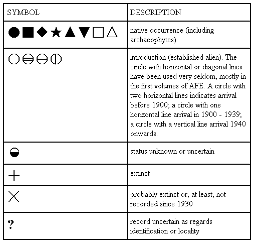
Old mapping symbols
Sixteen different types of symbols have been used in AFE volumes 1–11. If the map gives the areas of two or more taxa, the special symbols (+, x, ?, etc.) belong to the taxon marked by black dot, unless otherwise stated.
| STATISTICS FROM AFE 1–11 | ||
|---|---|---|
| STATUS | NUMBER OF SYMBOLS CALCULATED AT SPECIES LEVEL | PERCENTAGE OF ALL SYMBOLS, CALCULATED AT SPECIES LEVEL (n = 601,657) |
| NATIVE | 550,025 | 91.4 % |
| ESTABLISHED ALIEN | 36,507 | 6.1% |
| STATUS UNKNOWN | 5,622 | 0.9% |
| EXTINCT | 4,202 | 0.7% |
| POSSIBLY EXTINCT | 3,098 | 0.5% |
| RECORD UNCERTAIN | 2,203 | 0.4% |