
- Description
- Installation
- Working with the map window
- Making the map editable
- Entering the distribution data
- Saving the distribution data
- Printing
- Sending the data to Helsinki
- The structure of the distribution data (.afe) files
Description
The Atlas Florae Europaeae Data Editor (or AFEEditor, version 2010) is a program for creating text files that store the distribution data of taxa in Europe by editing the data files directly on a map. Alternatively the program can be used for viewing and editing distribution data files created elsewhere (e.g. data extracted from a floristic database).
The distribution data files are saved in the program installation directory and have the “.afe” extension. These files are kindly asked to send to the AFE Secretariat in Helsinki, where they will be incorporated into the main AFE database.
The AFEEditor program works under 32-bit Windows environment.
Installation
1) Download the AFEEditor2010.zip file.
2) Decompress the zip file, and run setup.exe program.
The software package consists of the following files:
- AFEEditor2010.exe => the executable program
- afegrid.csv => text file contain the territory and grid cell combinations and their coordinates
- basemap2.emf => base map with the grid cell boundaries
- basemap.emf => base map without the grid cell boundaries
- taxon.txt => list of taxa to be mapped in AFE vol. 16
By renaming the basemap2.emf to basemap.emf you can see the grid cell boundaries on the screen when creating the distribution data files. If you wish to use this option, be sure that you first rename the basemap.emf file to something else.
Working with the map window
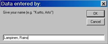
When the program is started, you first have to give your name (“Last name, first name”). This data is stored into the distribution data files created by the program.
Next the map of Europe is drawn onto the screen, with red circles showing the grid cell locations. The circles can be hidden by removing the tick mark from the Show Grid item in the Options menu. Distribution data can be edited only when the grid cells are visible.
The size of the map window can be changed using the control buttons in the upper right corner of the program window, and by placing the mouse cursor over the border of the map window, pressing the left mouse button down and then by dragging the window border to the desired size.
A portion of the map can be zoomed by pressing the right mouse button down and then by dragging a rectangle onto the map. To view the whole map again, right click any location on the map.
Making the map editable
To be able to edit distribution data,
1) the grid cell locations must be made visible by placing a tick mark to the Show Grid item in the Options menu
2) select the AFE territory for which you wish to record distribution data; the grid cells of this territory appear as red circles on the map
3) select a taxon using the New or Open command of the File menu. The name of the selected taxon is shown in the upper left corner of the window with bold text.
- The New command opens a selection listing, in alphabetical order, the taxa to be mapped in Atlas Florae Europaeae. The names are read from the taxon.txt file in the program installation directory. It is also possible to write an unlisted taxon into the text box. However, this name will not be automatically stored into the taxon.txt file. The taxon.txt file can, however, be edited manually using a text editor or word processing program. If there already is a distribution data file for the selected taxon, the program opens that instead of creating a new file.
- The Open command displays a dialog box listing the distribution data files for the taxa, distribution data of which has already been edited. Select a file to view or edit its distribution data. The distribution data files are located in the program directory, and their names are of the format taxon name.afe (for example, Comarum palustre.afe). The structure of the .afe files is explained below.
To make the data entry to a certain grid cell possible, the grid cell must be made active by selecting it with the left mouse button. The selected grid cell is then surrounded by a red square and its name (e.g., 35VLH3) is shown in the upper left corner of the window in bold text.
Entering the distribution data
After a taxon has been selected, and the map has been made editable by activating the Show Grid item in the Options menu, and a grid cell has been selected for record entry, the following type of data can be entered in the uppermost part of the program window:
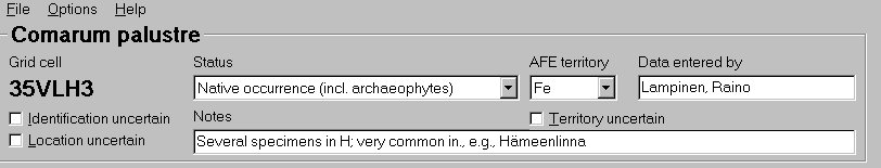
Status. The combo box displays eight choices to select from.
The status combo box can be activated by selecting it with the mouse or the tabulator. Once the combo box is active, the values of status can be chosen by mouse, by writing the first character of the status description, or by the arrow keys.
After a certain status has been selected, the corresponding map symbol is drawn onto the map as shown in the image below.
MAP SYMBOL EXPLANATIONS:
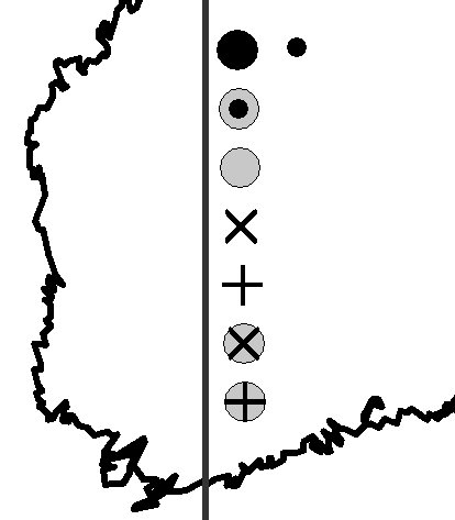
- black dot = native occurrence (incl. archaeophytes), present
- grey dot with a small black dot = status unknown or uncertain (ie., established, but not clear whether native/archaeophyte, or a younger introduction); present
- grey dot = introduced (established alien); present
- X = native or archaephyte, probably extinct
- cross (+) = native or archaeophyte, extinct
- grey dot with a X = introduced (established alien), probably extinct
- grey dot with a cross = introduced (established alien), extinct
- small black dot = identification, location or both uncertain (Note: status category not is not shown)
The “absent” value can be used to remove a record from the map.
Note that the symbols have changed from those used by the AFE Date Editor program during the preparation of AFE vol. 13!
AFE territory. The combo box lists, in alphabetical order the territories used in AFE. When a new cell without a territory abbreviation is selected, the territory last chosen will be copied.
Territory uncertain. Place a tick mark into the check box if the AFE territory is uncertain (e.g., old records from imprecisely described localities cannot sometimes with certainty be assigned to a certain AFE territory if the country boundaries have changed in the area).
Data entered by. When a new cell without the AFE collaborator name is selected, the value will be copied from the last selection with a collaborator name. Note that this value will be used to store the name of the person that provides the data form AFE by using the software – it does not mean the person(s) who originally recorded a certain taxon in the selected grid cell (this kind of data may be stored to the text box “Notes”).
Identification uncertain. Place a tick mark into the check box if the identification of the taxon is uncertain. The record will be shown as a small black dot in the map. Note that you must also select a status category other than absent to see the symbol on the map (and store the record into the distribution data file).
Location uncertain. Place a tick mark into the check box if the the grid cell is uncertain. The record will be shown as a small black dot in the map. Note that you must also select a status category other than absent to see the symbol on the map (and store the record into the distribution data file).
Notes. A text box for entering comments on the record source and for giving explanatory notes on the selection of the values of status and other items. The length of the text that can be entered is not limited to what is shown in the program window (max 64,000 characters).
Saving the distribution data
The Save command in the File menu saves the distribution data into an ASCII text file in the program installation directory. These distribution data files have the .afe extension. A separate .afe file will be created for every taxon. The structure of these files is explained below.
In addition, the data is automatically saved into a distribution data file when the program is closed from the Exit command in the File menu or from the upper right corner of the program window. Similarly, the distribution data file for the current taxon is automatically saved when the Open or New command is chosen from the File menu.
Moreover, the distribution data files (.afe) can be created outside the AFE data editor program, and can be read into the program after placing them into the program installation directory.
After exiting the program, please do take backup copies of the distribution data files.
Printing
The Print command in the File menu prints the map to the default printer. The printer settings can be adjusted by the Printer Setup command in the File menu. If the map has been zoomed, the area within the rectangle used in selecting the zooming area will be printed. The name of the current taxon will be printed to the upper left corner of the map. The circles showing grid cell locations will be printed only if the Show Grid item of the Options menu is on.
Print to file option in the Printer Setup dialog box makes it possible to create encapsulated postscript (.eps) files.
Sending the data to Helsinki
When ready, the distribution data files (*.afe files in the program installation directory) are asked to send to Helsinki where they are incorporated into the central AFE database.
The structure of the distribution data (.afe) files
The distribution data files have the .afe extension and they are stored in the program directory. They are CSV files (comma separated value files). The values of the different variables are separated by commas and text variables are placed within quotation marks. The .afe files are created separately for each taxon. The first line contains the taxon name and other lines the distribution data for each grid cell in which the taxon has been recorded. An example for Fragaria viridis in Fe:
“Fragaria viridis”
“34VDM1″,16,0,”Fe”,0,”Lampinen, Raino”,”2004-11-22″,”Eckerö, Finström, Geta, Jomala, Lemland, Mariehamn, Saltvik, Sund; latest specimen from Finström and Lemland 1993 (Hæggström, H).”
“34VDM3″,16,0,”Fe”,0,”Lampinen, Raino”,”2004-11-22″,”At least Lemland (church), Sund (e.g. Bomarsund), according to H specimens”
“34VEM2″,16,0,”Fe”,0,”Lampinen, Raino”,”2004-11-22″,”E.g. V. Korppoo, Jurmo island 1987, abundant on a meadow (H661452; Risto Murto 5195 & Marja Koistinen); numerous other records from Jurmo. Also recorded in Lökholmen and Trunsö islands (Nauvo) and Björkö (Korppoo). Mapped in Eklund 1958 (recorded from six islands on warm meadow slopes). Rautiainen & Laine 1989, p. 56, sought in vain from Lökholm and Sandholm in Nauvo, as well as from Björkö and Jurmo Huvudskär, and mentioned new finds only from Jurmo main island and Trunsö.”
The records of the .afe files consists of eight parameters as explained in the table below (example values of the first record of the Fragaria file listed above are shown in the first column):
| 34VDM1 | Grid cell code |
| 16 | Status code number. — Value explanations: 11 = introduced (established), extinct;12 = introduced (established), probably extinct; 13 = native or archaeophyte, extinct; 14 = native or archaeophyte, probably extinct; 15 = introduced (established alien), present; 16 = status unknown or uncertain (not certain whether native (incl. archaeophytes) or a recent introduction), present; 17 native occurrence (incl. archaeophytes), present. Note that these values have changed from those used during the preparation of AFE vol 13. |
| 0 | Accuracy code. — Value explanations: 0 = accurate; 1 = identification uncertain; 2 = location uncertain; 3 = both identification and location uncertain. |
| Fe | AFE territory abbreviation. |
| 0 | AFE territory accuracy code; number 0 for accurate records, 1 for records with uncertain territory. |
| Lampinen, Raino | Name of the data recorder; format “lastname, first name(s)”. |
| 2004-11-22 | Date of the data entry/latest date of change for the grid cell records. The date is taken from the computer clock and its format depends on the local settings. The distribution data file can include different dates if the records have been edited during several days. |
| Eckerö, Finström, Geta, Jomala, Lemland, Mariehamn, Saltvik, Sund; latest specimen from Finström and Lemland 1993 (Hæggström, H). | Data from the Notes text box, giving information on the record source etc. |